

Geology and Soils
The National Park has a unique and visible geological character that is a fundamental part of its outstanding landscape and scenery which has been formed and re-shaped by complex processes such as plate tectonics, glaciations, weathering and erosion. Eryri has played an important role in the development of earth sciences, with many notable geologists visiting to undertake fieldwork. It contains a wealth of nationally and locally important geological and geomorphological features, and has a wide-range of soil types that are influenced by the underlying geology and rock types and also the land management practice/activity upon it.
Human action has, over a considerable period of time, impacted in various ways on geological and soil resources through activities such as quarrying; the clearance of native woodlands for agriculture; the draining of upland bogs; commercial afforestation and erosion due to recreational activities and overgrazing.
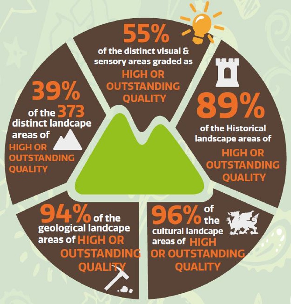
LANDMAP
LANDMAP is a tool to help sustainable decision-making and natural resource planning at a range of levels from local to national. Five spatial datasets are included, which are:
- Geological landscape
- Landscape habitats
- Visual and sensory
- Historic landscape
- Cultural landscape
The image below shows the percentage of areas within Eryri National Park that are graded as being of high or outstanding quality within their relevant categories.
Regionally Important Geodiversity Sites
RIGS were designated as Regionally Important Geological/Geomorphological Sites in the UK Nature Conservancy “Earth Science Conservation in Great Britain: A Strategy” (1990), being of a standard worthy of recognition and protection as non-statutory sites, to complement the SSSIs and NNRs under statutory protection. RIGS sites in Wales are now known as Regional Geodiversity Sites.
Natural Resources Wales have contributed to the all Wales audit of RIGS through financial and technical support. The audit which began in 2003, is the first comprehensive national assessment of second-tier sites in Wales. It was undertaken largely by the local RIGS groups and NRW Earth Scientists with the majority of the funding coming from the Aggregates Levy Sustainability Fund, but with a financial contribution by NRW to the project in North Wales. The audit led to the standardisation of the site documentation, digitisation of site boundaries to a common format and ensured that the landowners and planning authorities were informed of the RIGS.
A major input from NRW was the development of the GIS database for the project where all of the 600 or so sites registered so far were digitised by NRW. NRW currently hosts these GIS data.
There are 47 RIGS in the National Park.
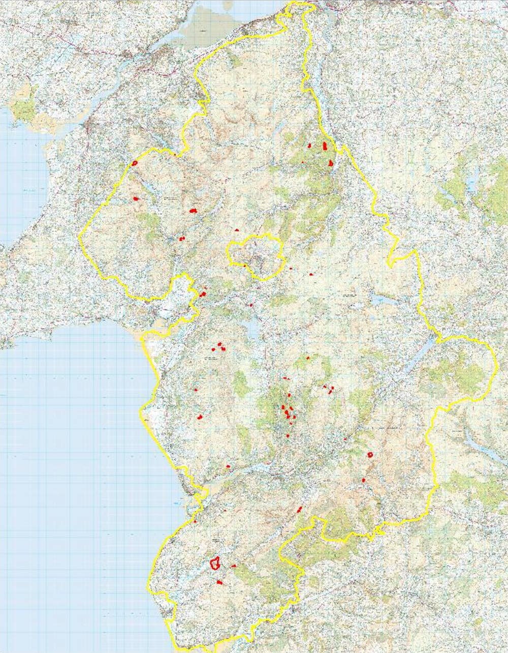
Location of Working Mineral Sites in Eryri
Braich Ddu
Commodity: Slate Waste
Other Mineral Types: Building Stone
National Grid Easting: 271970
National Grid Northing: 338440
Craig y Tan
Commodity: Igneous and Metamorphic rock
Other Mineral Types: Building Stone
National Grid Easting: 271349
National Grid Northing: 336224
Ty’n-y-Coed
Commodity: Slate Waste
Other Mineral Types: Secondary Aggregate
National Grid Easting: 265030
National Grid Northing: 315275
Peat Soils and Carbon Sequestration
Carbon sequestration is where atmospheric carbon dioxide is removed by natural or artificial processes and stored. Peat soils in Wales provide a significant carbon store The current estimate8 of the extent of deep peat soils (depth ≥0.5m) in Wales is 90,995ha, some 4% of the’ total land area. They provide Wales’ largest terrestrial ecosystem store of carbon, estimated at around 157mt.
It is estimated that if they were returned to near-natural condition, their climate change mitigation potential is 300,000 tonnes of carbon dioxide per year. This is roughly the equivalent of 5% of all Welsh transport related emissions.
Approximately 30% of Wales’ peak bog is found within the boundaries of Eryri National Park. In order to get a more accurate assessment the National Park Authority has commissioned the mapping and evaluation of peat, peatland habitats, associated ecosystem services and restoration priorities within Snowdonia. The outputs of this work will include:
- a GIS based inventory of deep peat (>0.5m) deposits in and within a variable buffer of the National Park boundary;
an estimate peat carbon stocks based on peat depth and peatland morphology to identify priority carbon storage sites within the project area; - a map and evaluation of the habitat cover and condition of peatlands within and adjacent to the National Park at a plant community level such as NVC and/or Phase I. Habitat cover to be grouped into a series of classes which reflect the broad habitat condition; Maps and habitat cover extent tables will be produced showing the extent of overlap of these broad habitat cover classes on peat;
- a map showing drainage features (grips) on deep peat within the study area following methodology developed by BGS;
a map of emission “hotspots” and restoration priorities by cross mapping emission factors to defined habitat cover categories to yield mapped outputs of emissions according to pre-agreed classes; - the identification of key opportunities where restoration could be focussed to reduce emissions. This will require collation of evidence relating to habitat character and condition, topography (primarily slope) and proximity to rivers and lakes to identify priority sites for restoration. A third GIS layer to be developed reflecting ‘restoration urgency’ based on the vulnerability of peatland sites to further damage and carbon loss (e.g. severely eroded sites);
The outputs of this work, some of which will be incorporated into this document when they become available, will enable the Authority to develop a peatland strategy to help guide future restoration works as an element of sustainable land management and to help quantify some of the principal ecosystem service benefits associated with restoration. The map below shows the extent of peat soils in Snowdonia.
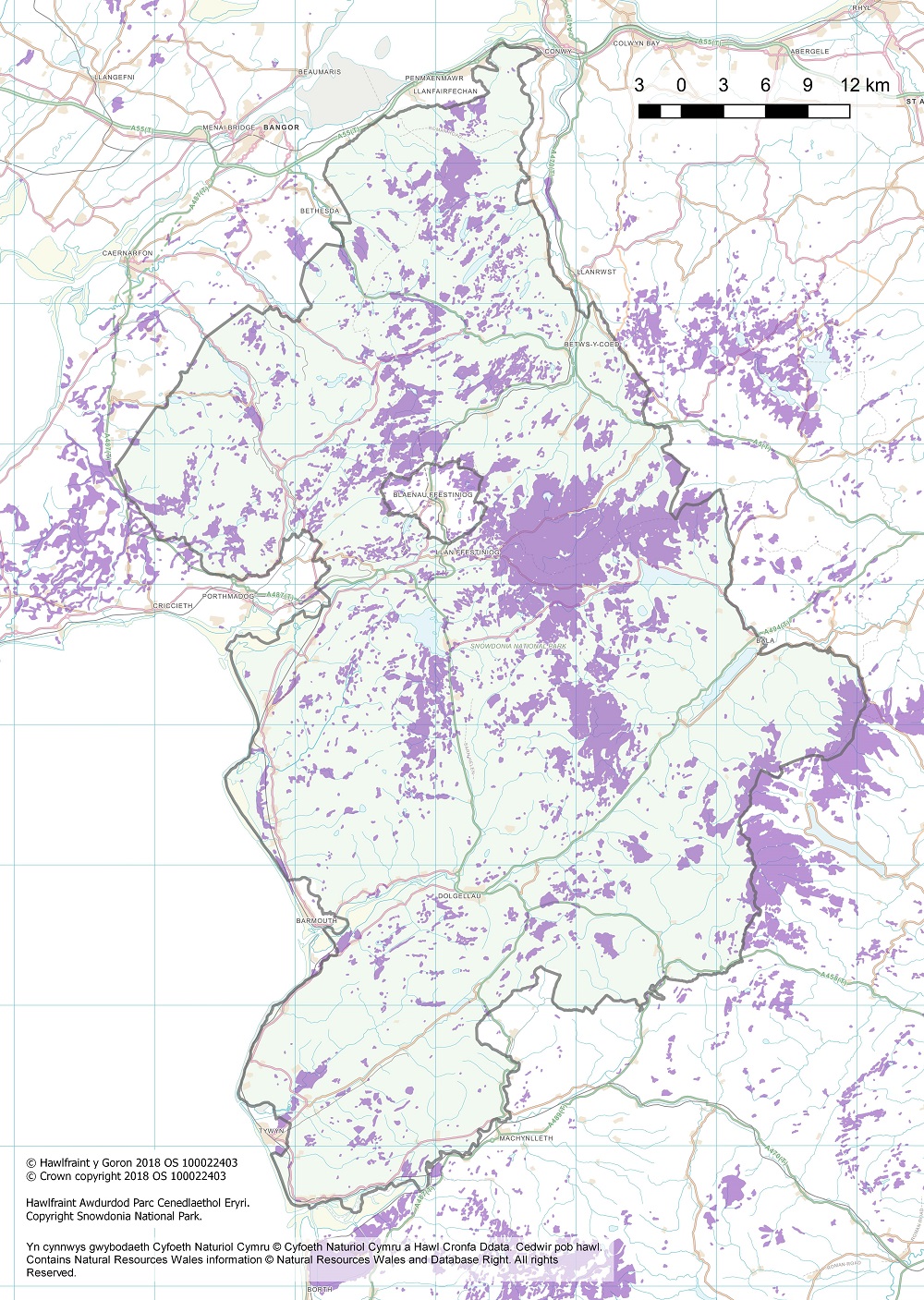
Above: Map showing the areas of peatland within Eryri National Park outlined in green. The areas shown in purple display areas of peatland.
Peat percentage within Eryri National Park
Total area: 213,969 hectares
Peatland area: 25,460 hectares
Percentage peat: 12%
Total carbon stocks in peat and non-peat soil within Eryri National Park
Peat C stock (t): 16,968,000
Average Peat C stock (t/ha): 666
Non-peat C stock (t): 15,735,000
Average Non-peat C stock (t/ha): 83
8 A Snapshot of the State of Wales’ Natural Resources 2015
Woodlands
Extent of Woodland Coverage
Wales is one of the least wooded countries in Europe with the area of woodland at 31 March 2010 estimated to be 303,500ha. This is 14.3% of the total land area compared to an EU average of 37%per cent. Natural Resources Wales (NRW), on behalf of the Welsh Government, manages 37% of the Welsh woodland which equates to 114,000 hectares. A further 190,000ha are in private ownership.
Timber from Welsh conifer woodlands is used mainly in construction, fencing and packaging.
Eryri National Park has a woodland cover of approximately 18%, which equates to some 38,000ha (12.5% of Welsh woodland cover). Whilst large areas of Eryri would once have been afforested with native broadleaf forests, human actions have reduced this over several millennia such that native woodlands now equate to approximately 5% of the National Park’s woodland cover (11,000ha).
The Ancient Woodland Inventory (AWI) identifies woodlands that have had continuous woodland cover for some centuries. Studies show that these woodlands are typically more biodiverse and of a higher nature conservation value than those developed recently or those where woodland cover on the site has been intermittent. These woodlands may also be culturally important. The new updated inventory (AWI 2011) indicates that there are around 95,000ha of ancient woodland in Wales.
- Ancient Semi-Natural Woodland (ASNW) – broadleaf woodlands comprising mainly native tree and shrub species which are believed to have been in existence for over 400 years
- Plantation on Ancient Woodland Sites (PAWS) – sites which are believed to have been continuously wooded for over 400 years and currently have a canopy cover of more than 50% non-native conifer tree species
- Restored Ancient Woodland Sites (RAWS) – woodlands which are predominately broadleaves now and are believed to have been continually wooded for over 400 years. These woodlands will have gone through a phase when canopy cover was more than 50% non-native conifer tree species and now have a canopy cover of more than 50% broadleaf9
- Ancient Woodland Site of Unknown Category (AWSU) – woodlands which may be ASNW, RAWS or PAWS. These areas are predominantly in transition and existing tree cover is described as ‘shrubs’, ‘young trees’, ‘felled’ or ‘ground prepared for planting’.
Ancient woodland and site of unknown category
Wales: 713.4 ha
Snowdonia: 5444.1 ha
Ancient semi natural woodland
Wales: 41,786.53 ha
Snowdonia: 3854.37 ha
Plantation on ancient woodland site
Wales: 25,748.89 ha
Snowdonia: 3033.07 ha
Restored Ancient woodland
Wales: 21,961.58 ha
Snowdonia: 1986.66 ha
Total
Wales: 94,941.1 ha
Snowdonia: 9,578.5 ha
It is estimated that current carbon sequestration by trees in Wales amounts to some 1.42 Mt annually (approx. 3.8% of total carbon dioxide emissions) and the Woodland Carbon Code is helping to improve this. Wales’ status as a net sink for carbon is a result of a low incidence of land use change and a relatively young forest resource.
Conifer UK
Stems: 189
Other: 51
Total: 340
Conifer Wales
Stems: 23
Other: 18
Total: 41
Broadleaved UK
Stems: 109
Other: 136
Total: 245
Broadleaved Wales
Stems: 14
Other: 17
Total: 31
Total UK and Wales
UK: 534
Wales: 72
Data from McKay et al, (2003) calculated assuming 50% of biomass is C; excludes fine roots and broadleaf foliage (assumed deciduous); excludes privately owned woods <2ha
Summary of carbon stocks (MtCO2) in standing tree biomass of GB and Welsh woodlands
Separate figures for the carbon stock in trees in the National Park have not been published however as a starting point a very rough approximation can be made based on two calculations, firstly the apportionment (12.5%) of the Wales total of 72 MtCO2 to Snowdonia and secondly applying the estimated figures of 300 and 500 tCO2ha -1 respectively for Sitka spruce and oak stands to the c27,000 ha of Sitka spruce plantations and c11,000 ha oak woodlands in the National Park10.
Estimated Carbon stocks in the standing biomass of Snowdonia’s woodlands would be in the range of 9–13.6 MtCO2
Estimated components and proportions of in-forest stocks of Wales’ Forestry (MtCO2)
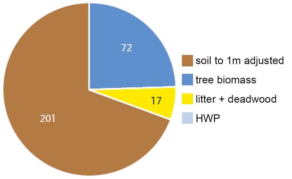
The diagram shows that soils, particularly the peaty gleys on which most of Eryri’s forests are planted account for a large majority of carbon stocks in woodlands.
This would amount to some 25.13 MtCO2 in woodland soils in Eryri.
The National Park Authority/Forestry Commission Native Woodland Accord aims to increase the area of native woodland within the National Park by 50% by 2050 and to ensure that all existing woodland is appropriately managed within the same period (Source: Snowdonia Biodiversity Action Plan).
Source: Peat Executive Summary Natural Resources Wales
The National Park Authority/Forestry Commission Native Woodland Accord aims to increase the area of native woodland within the National Park by 50% by 2050 and to ensure that all existing woodland is appropriately managed within the same period (Source: Snowdonia Biodiversity Action Plan).
9 Information sources do not identify whether broadleaf trees are native to a specific site, therefore an assumption has been made that they are native. The phrase ‘restored ancient woodland’ describes woodland which appears, with the use of remote sensing techniques, to have returned to a more natural condition. The inventory designation does not mean that the woodland is fully restored or that it is in good ecological condition. Active restoration work may well be essential to consolidate improvements in condition.
10 Figures derived from “Understanding the carbon and greenhouse gas balance of forests in Britain.” Forestry Commission 2012.
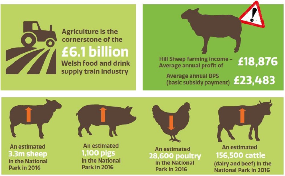
Agriculture
The predominantly moist temperate maritime climate combined with topography of Wales means that agriculture is primarily focused on raising livestock for meat and milk production. Red meat production (sheep, cattle, pigs) contributes the largest share, some 43% of total the Welsh Agricultural Output. The growing of arable or horticultural crops and raising poultry or pigs are smaller sectors.
Upland sheep or cattle farms comprise 31% of the total with 4% dairy. Currently there are about 9.7 million sheep in Wales (about a quarter of the total number of sheep in the UK). and around 1.1 million cattle.
The Less Favoured Areas (LFAs) designation covers 76% of the agricultural land area in Wales. These areas are defined as land where agricultural productivity is limited by topographical and climatic constraints such as steep slopes, poor soils and high rainfall. The Welsh Agricultural Statistics 2012-2013 showed there was 63,366 ha of woodland (20% of all woodland in Wales) on agricultural holdings in 2013, primarily located in Less Favoured Areas.
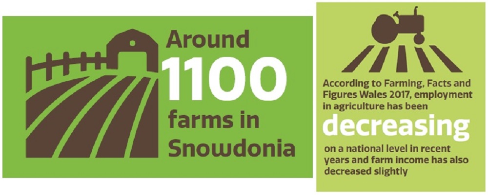
The Authority recognises the importance of agriculture to Eryri by having dedicated staff to work alongside farmers in the delivery of National Park Purposes. In recent years, the Agriculture Liaison Section has been instrumental in drawing down European funding to enable farmers to undertake a number of land management projects.
Additional to the delivery of grants for land management the section also provides technical and policy advice/ support and determines permitted developing (planning) applications for agriculture within the National Park.
Agricultural Land Classification
The Agricultural Land Classification system provides a mechanism for assessing the quality of agricultural land to make informed decisions about its future use. The classification is based on the long-term physical limitations of land for agricultural use. Factors affecting the grade are: climate, site and soil characteristics and the important interactions between them. Figure 6 presents a map showing the classifications for land within the National Park. The land is graded 3 (good/moderate) and below.
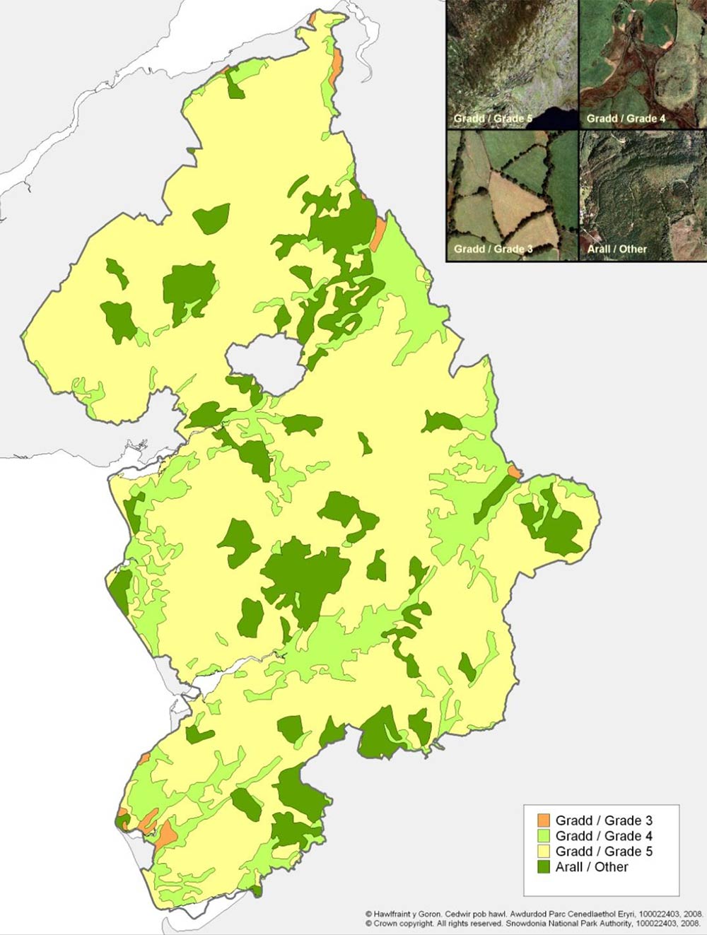
Figure 6: Agricultural Land Classification for the National Park (Source: Snowdonia National Park Authority, 2008)